Moisture Updates - July 19, 2023
Synopsis
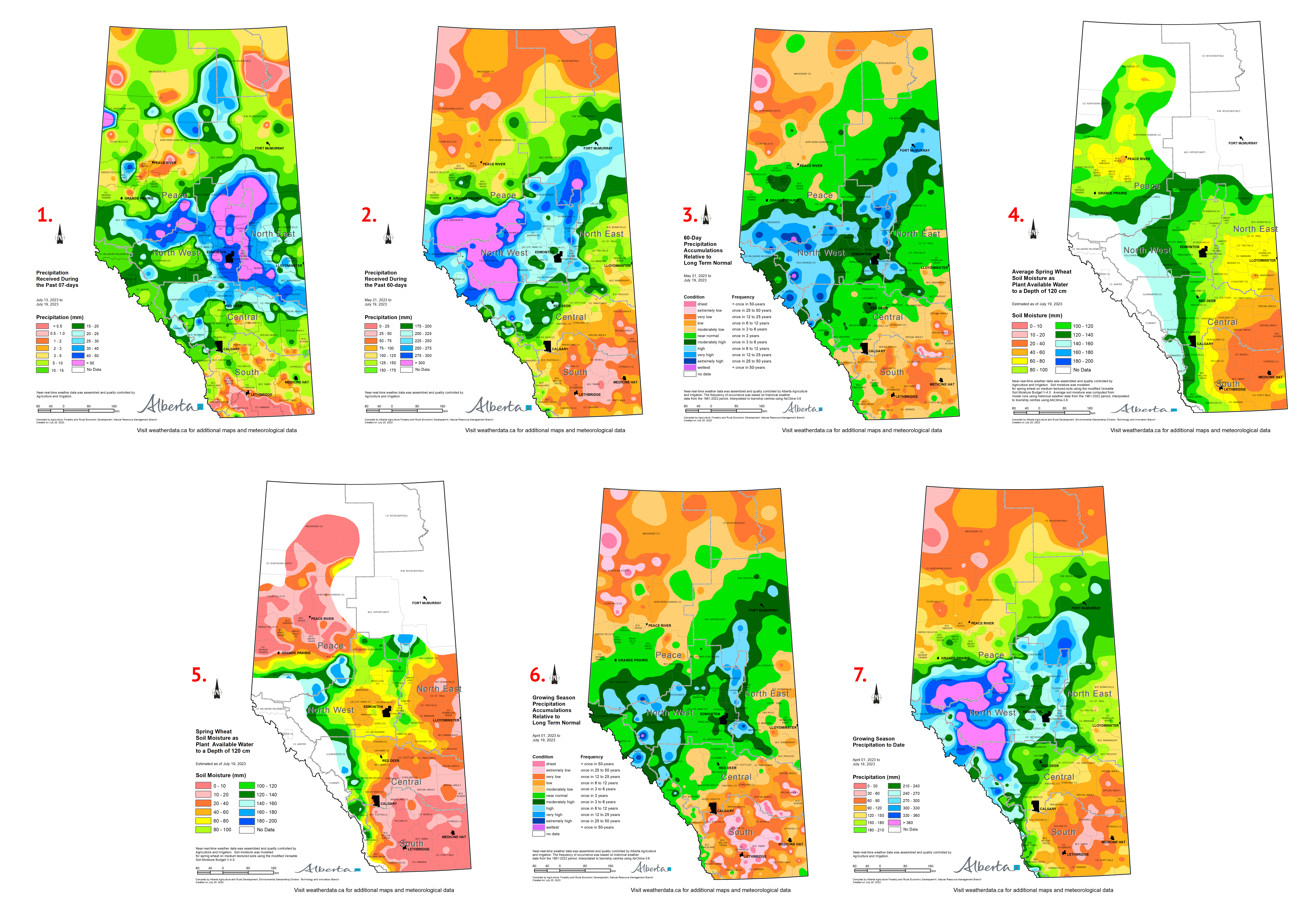
Map 1: Since the last report (July 12, 2023) precipitation activity was concentrated between townships 35 to 75, with localized rainfall occurring near the B.C. border in the county of Northern Lights and Clear Hills county on July 17 and 18. Northern Sunrise County, the Municipal District of Opportunity, Wood Buffalo I.D & R.M, Mackenzie County, the Municipal District of Spirit River, and the Municipal District of Fairview received 20 to 50 mm of precipitation for this seven day period. Forecasts for the province continue to predict significant rainfall events for the coming week and with this we will see cooler temperatures, although these conditions may be short lived and these storms are likely to hit variably throughout Alberta.
Recent Precipitation Patterns over the Past 60-days
Maps 2 &3: For the period of May 21 to July 19 the Northwest and Southeast bordering corners have missed out on much of the rain that was received in the Peace, North West, and Northern sections of the North East (Map 2). Most of the rainfall from this 60 day span was recorded in M.D of Greenview, M.D. of Big Lakes, Woodlands C.O., Yellowhead C.O., Clearwater C.O., I.D. of Jasper, and Brazeau C.O. in excess of 300 mm whereas Mackenzie C.O. and M.D. of Taber have only received less than 25 mm. Recent precipitation events over the last 60 days have shown just how variable the precipitation received by the province has been this year (Map 3). Climate monitoring stations within the Alberta Climate Information Service network have collected data to indicate we have both once in 50 year dry and once in 50 year wet conditions. Although we have experienced more rainfall recently, it has unfortunately come too late for some areas of the province.
Soil Moisture Reserves as of July 19, 2023
Maps 4 & 5: Soil moisture reserves current of this growing season (Map 4) continue to express the variability from recent precipitation events with much of the agricultural areas with 60 mm to upwards to 160 mm available moisture to a depth of 120 cm. The lower South East corner of the province has significantly less soil moisture reserves as of July 19 with areas deprived of moisture at reserves ranging from 20 mm to 40 mm available. Historical average soil moisture levels derived from the 1961-2022 period are shown in Map 5 give a better picture of just how dry the agricultural areas of the province have been, and more rural municipalities have been added to the agricultural disaster list in recent weeks.
Growing Season Precipitation as of July 19, 2023
Maps 6 & 7: Looking at the bigger picture of the 2023 growing season precipitation accumulation relative to long term normal (Map 6) it is clear many areas of the province have been very dry. Although the North West and North East indicate near normal and wetter conditions this is only due to recent precipitation events. These recent storm events have hit heavy in the North West with accumulations of over 360 mm for our current growing season (Map 7), areas of Mackenzie County void of precipitation continues as well as the dry Southeast pocket of the province.
Perspective
Friday thunderstorms are expected to hit the Rocky Mountains and sweep East through the foothills beginning in the late afternoon, a heavier system expected to bring over 20 mm/h is forecast for the North West and Peace on Saturday in the morning with more widespread activity across the province to continue over the weekend.
Contact Us
Saddle Hills
Junction of Hwy 49 & Secondary Hwy 725
RR1, Spirit River AB
T0H 3G0
T. 780-864-3760
Fax 780-864-3904
Toll-free 1-888-864-3760
frontdesk@saddlehills.ab.ca
Sign up to our Newsletter
Stay up to date on the Saddle Hills activities, events, programs and operations by subscribing to our eNewsletters.

