Moisture Situation Update As Of November 18th
Synopsis
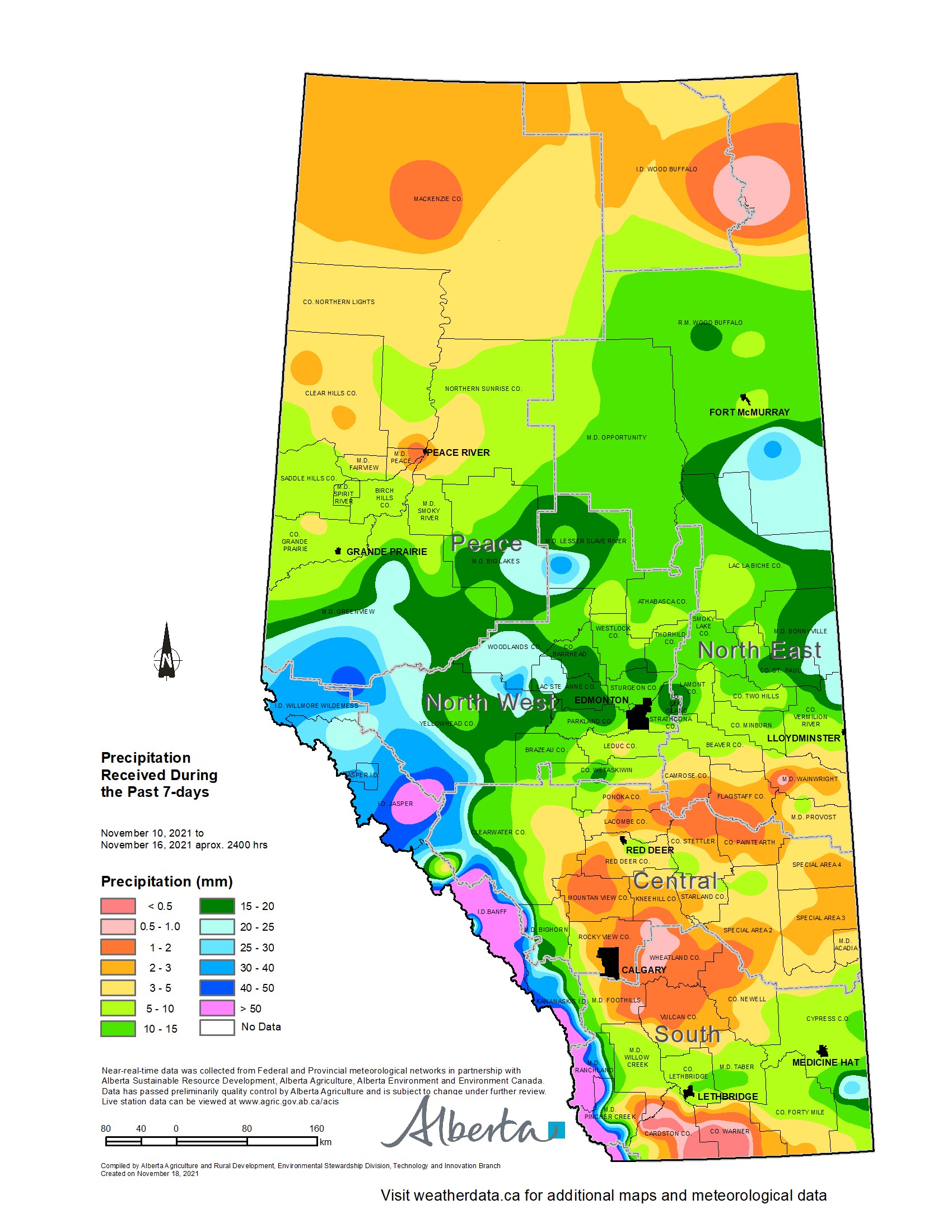
This past weekend (Nov. 13th-14th) a major storm system brought moisture to many areas across the north-half of the province and also some parts of Southern Alberta (map 1). North of Red Deer most of the precipitation fell as snow, fueling hopes for a healthy winter snowpack. This latest moisture adds to the wetter weather trends that returned across much of the west-half of the province starting in mid-August, following an exceptionally hot and dry summer.
Unfortunately, dry conditions are still persisting through much of the east half of the province, and throughout most of the Southern Region.
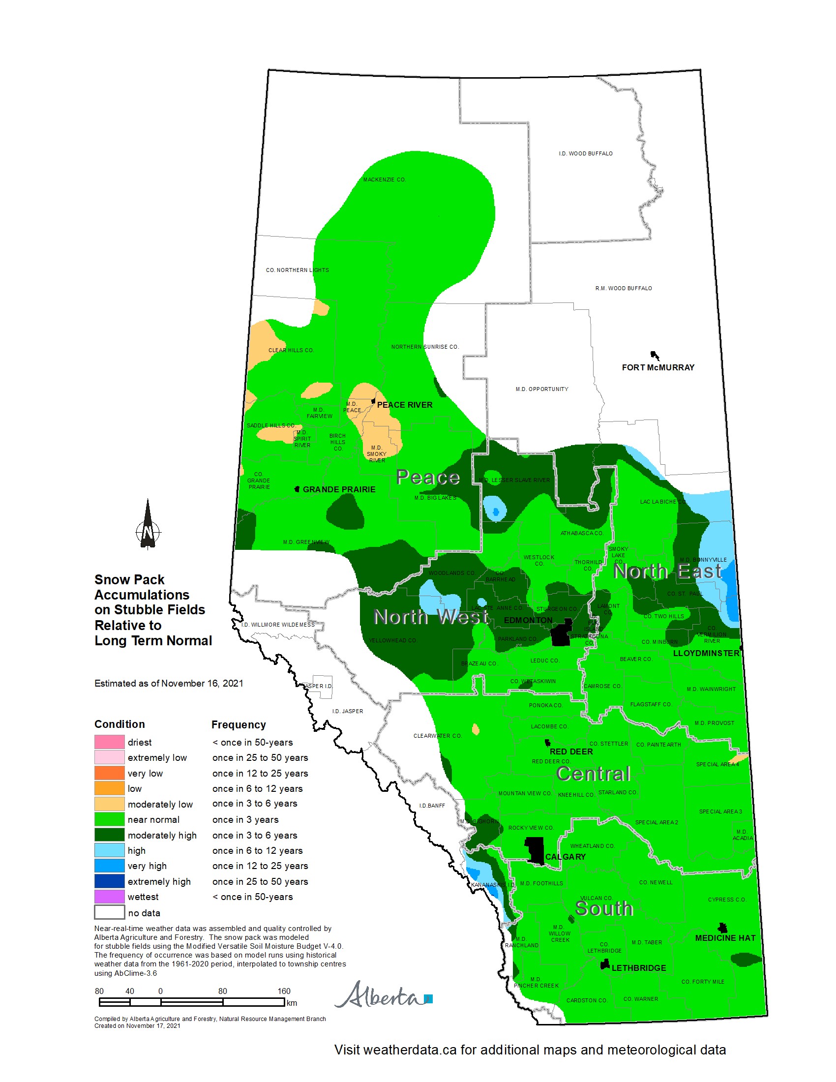
Snow Pack accumulations as of November 16, 2021. (map 2 and Map 3)
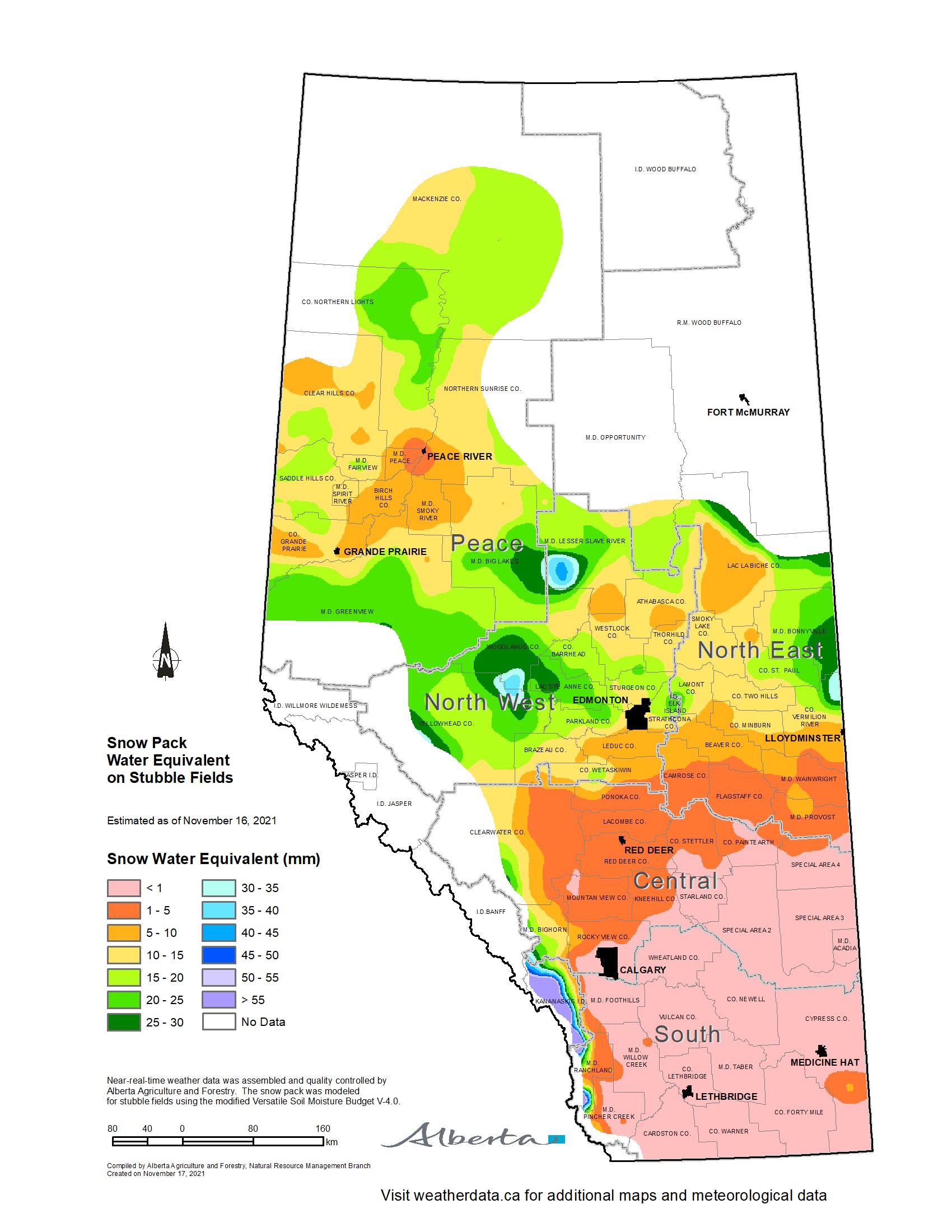
Generally north of Wetaskiwin, most agricultural areas are currently under at least 10 cm of snow, ranging up to 20 cm in parts of the North West and Eastern Regions. In contrast, lands south of Red Deer generally remain snow free (map 2).
For this time of year current snow packs are at least near normal across the province, with above normal snowpacks found roughly along the Yellowhead highway between Lloydminster to Edson
90-day precipitation accumulations as of November 16, 2021.
Since mid-August, upwards of 70 mm of precipitation has fallen across parts of Peace Region, the Northern portions of the Eastern Region and through the western portions of the North West and Central Regions Some lands through the North West and southern Peace Regions have seen upwards of 125 mm. This has helped replenish moisture supplies.
Across the east-half of the province, generally south of the Yellowhead highway down to the US border, many areas remain dry with less than 50 mm recorded (map 4). The driest areas are found through parts of the Special Areas and the south-eastern parts of the Southern Region, with some lands receiving less than 30 mm over this 90-day time frame.
Following the hot dry summer, precipitation patterns have returned to at least near normal across about 2/3rds of the agricultural areas, lying mostly north of a line running between Olds and Lloydminster (map 5). South of this line, below normal precipitation patterns continue to persist.
Soil moisture reserves relative to long term normal as of Oct 31 2021.
Despite recent moisture, only a few areas have had soil moisture reserves rebound to a near normal condition for this time of year. Parts of the North East are still estimated to have reserves this low, less than once in 50-years. However, this marks a vast improvement over the reserves that were in the ground by mid-August, were large areas of the province were estimated to have reserves this low less than once in 50-years.
Perspective
Spring is still a long way off, and there is ample time to accumulate reasonable snow packs and receive timely rains in the early spring. The meteorological record is replete with abrupt shifts between wet and dry spells. Thus utilizing recent weather trends to predict future weather trends is simply not advisable. In Alberta, 2020 is the most recent example of this, with overly wet conditions that persisted into July that then unexpectedly shifted into the long dry pattern that we have seen since then.
Contact Us
Saddle Hills
Junction of Hwy 49 & Secondary Hwy 725
RR1, Spirit River AB
T0H 3G0
T. 780-864-3760
Fax 780-864-3904
Toll-free 1-888-864-3760
frontdesk@saddlehills.ab.ca
Sign up to our Newsletter
Stay up to date on the Saddle Hills activities, events, programs and operations by subscribing to our eNewsletters.