Moisture Update November 2022
Saddle Hills County Ag Services Department regularly updates local moisture conditions for agricultural producers.
Synopsis
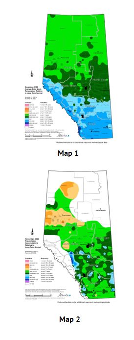
(map 1 and map 2)
Over the month of November, previously warmer than normal weather patterns have generally been displaced by a varied mix of warm and cold spells.
For the north-half of the province the balance was near normal temperatures for the month (map 1), while across the south-half of the province below average temperatures prevailed, generally intensifying toward the US border.
Moisture patterns were generally near normal (map 2), with areas in the central Peace Region trending to the dry side of the spectrum, while wetter than normal weather prevailed through roughly 50% of the lands lying south of the Yellowhead highway.
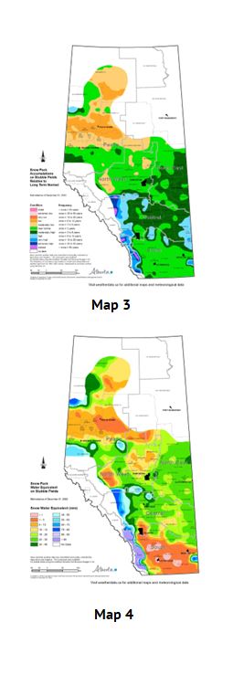
Snow pack accumulations as of December 1, 2022.
(map 3 and map 4)
Currently across much of the Peace Region, snow packs are generally below normal for this time of year, trending below one in 6-year lows through the central and northern parts (map 3).
In contrast, snow pack accumulations throughout much of south-half of the province are near to above normal, trending at least 6 year highs across the Special Areas as well as through some smaller pockets through the Central parts of the province.
Across the mountains a foothills snow accumulations were greater still, with some areas tending upwards of one 25-year highs.
Total water contained in the snow pack, known as Snow Water Equivalent (SWE), is variable across the provinces agricultural areas, ranging from bare fields in parts of southern Alberta and near bare fields across parts of the northern-half of the Peace Region, to upwards of 50 mm of SWE in some areas north of Red Deer (map 4).
Perspective
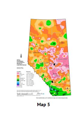
(map 4 and map 5)
November has ushered in a marked change from the warm and dry weather that dominated across most of the province since at least early August, right until the end of October (map 5). Consequently extremely dry lands in the North East and through much of the Central Region are starting to build moisture reserves in the snow packs (map 4), with total SWE in the 20 to 30 mm range. In comparison, during an average winter (Nov-March), these lands typically receive 80 to 100 mm of moisture, which is just under 25 % of the total average annual accumulations (400 to 450 mm).
Continued near normal to above average precipitation will be welcome in many parts of the province with the hopes that favorable spring runoff will replenish low surface water supplies and contribute to early spring soil moisture reserves.
Contact Us
Saddle Hills
Junction of Hwy 49 & Secondary Hwy 725
RR1, Spirit River AB
T0H 3G0
T. 780-864-3760
Fax 780-864-3904
Toll-free 1-888-864-3760
frontdesk@saddlehills.ab.ca
Sign up to our Newsletter
Stay up to date on the Saddle Hills activities, events, programs and operations by subscribing to our eNewsletters.