Moisture Updates - March 30, 2023
Synopsis
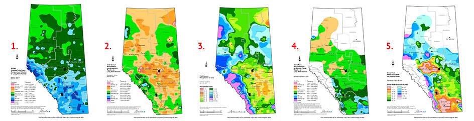
Maps 1 & 2: Winter is stubbornly refusing to relinquish its grip this spring. Over the past 30-days, temperatures have been colder than normal (Map 1). Over this period, generally sunny skies have resulted in day time temperatures managing to get well above freezing on many days, but persistent well below freezing temperatures overnight have dramatically slowed down the spring melt. This is particularly true for most of the south-half of the province were its not uncommon for the ground to be snow free at this time of year.
In general, areas south of the TransCanada Highway have been receiving near normal overwinter precipitation patterns. However the absence of chinooks and warm spells have left some moisture intact ahead of the coming melt. This should bode well for providing pastures with a good early start when they finally break dormancy.
Across the central parts of the province, winter precipitation has been well below normal but lingering snow packs in many areas and the likely hood of a slow melt, may see some of this moisture making its way into the soil and becoming available for early growth as the weather turns warmer. Despite this, additional spring moisture will be needed early to help get perennial crops off to a good start and begin replenishing below average soil moisture reserves.
Across the North East, conditions were exceptionally dry this fall, but near normal to above normal overwinter moisture has resulted in healthy snow packs that still contain enough water to provide ample runoff and the promise of a good start towards rebuilding depleted soil moisture reserves.
Across the Peace Region, snow packs are quite variable with some areas having below average snowpacks along with but many other areas that are near normal. Spring comes later in this part of the country and there is still ample time to receive moisture ahead of the new spring growth period.
Cold Season Precipitation Accumulations
Maps 2 & 3: Since November 1st, most parts of the province have received below normal overwinter precipitation accumulations (Map 2), with large parts of the Central, North East, North West and Peace Regions experiencing accumulations this low, on average, less than once in 6 to 12 years, along with several widely scattered pockets trending to less than one in 12 to 25 year lows. Some large areas east of Highway 2 between the Yellowhead and the TransCanada Highways have received less than 40 mm over this winter (Map 3). Long term averages for these lands range from 60 to 70 mm, so generally, winter moisture deficits here are in the 30-40 mm range. Over all, a few days of wet weather this spring should help in the short-term to alleviate growing concerns centered on lack of moisture.
Snow Pack Accumulations
Map 4: During many previous years, snow packs are in full retreat at this time of year. However, a delayed end to winter this spring has resulted in the appearance of having generally near normal snow packs remaining at this time a year (Map 4), which seemingly contradicts the Cold Season precipitation accumulations discussed above. As such, lingering snow cover may prove to be advantageous in helping to offset soil moisture deficits, provided that melt remains slow and gradual. This may help improve soil moisture reserves somewhat, but it could also come at the cost of less surface runoff to fill dugouts, marshes, streams and lakes.
Currently snow water equivalents (SWE), remaining in the field, (amount of water if we melted the snow), are estimated to be less than 1 mm across parts of the south and even along some stretches of the Yellowhead Highway, west of Edmonton. Central parts of the province, were it’s been very dry, are estimated to contain 30 to 50 mm of SWE. This increases to well over 80 mm across parts of the North East and throughout most of the Peace Region. These areas currently have below normal soil moisture reserves so this yet to be released water will very beneficial for the landscape as a whole when winter finally loses its grip in the wake of our elusive spring.
Perspective
The growing season of 2023 still lies ahead and it’s too early to tell how current moisture levels will affect early crop growth. Suffice it to say the land is generally drier than normal, but there is time to receive adequate moisture. April is a complex month for weather forecasters and lingering snow packs will likely lead to some uncertainty in their longer range predictions of day time temperature regimes.
With cold air lingering we may just see active weather that brings much needed moisture, providing a wet air mass targets Alberta in the coming weeks. For spring seed crops June and July will be critical if precipitation patterns remain below normal. Fall seeded crops and perennials, on the other hand, will benefit most from early moisture both in the form of snowmelt and rain along with of course, warmer temperatures.
Contact Us
Saddle Hills
Junction of Hwy 49 & Secondary Hwy 725
RR1, Spirit River AB
T0H 3G0
T. 780-864-3760
Fax 780-864-3904
Toll-free 1-888-864-3760
frontdesk@saddlehills.ab.ca
Sign up to our Newsletter
Stay up to date on the Saddle Hills activities, events, programs and operations by subscribing to our eNewsletters.