Moisture Update - August 21, 2025
Precipitation
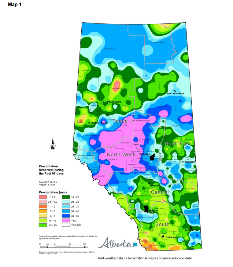
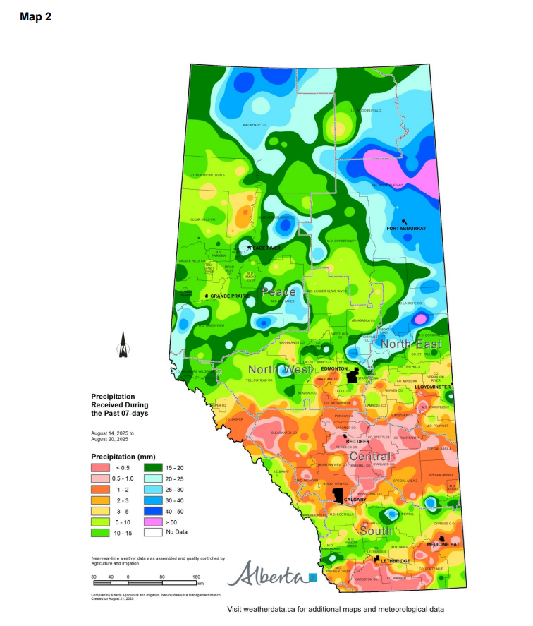
Maps 1, 2 & 3: The pattern of rainfall over the past two weeks was more typical for the province, with the north receiving more precipitation than the south.
The South Region received between 10 and 20 mm (Maps 1 & 2), which is typical for this time of year (Map 3). However, areas within Cypress County, Forty Mile County, and Special Area No. 3 received more than 20 mm, while municipalities such as Pincher Creek, Cardston, and Warner received less than 5 mm.
In the Central Region, precipitation ranged from 5 to 30 mm two weeks ago, but dropped to less than 3 mm this past week (Maps 1 & 2). This is slightly above the typical rainfall for this time of year (Map 3). The lower rainfall is favourable, as most crops have matured and harvest activities are underway.
The North East Region received between 15 and 30 mm of precipitation over the past two weeks (Maps 1 & 2). Meanwhile, the North West Region recorded the highest rainfall, with totals ranging from 20 mm to over 50 mm; well above the long-term average (Map 3). More modest rainfall occurred this past week, with several areas reporting less than 3 mm.
Rainfall across the Peace Region was variable (Maps 1 & 2). The southeast portion received from 25 mm to over 50 mm of precipitation, while the northern Peace Region, including Mackenzie and Northern Lights Counties, received 30 to 60 mm of precipitation. In contrast, areas within Grande Prairie, Clear Hills, and Northern Sunrise Counties received less than 20 mm over the past two weeks.
Temperature
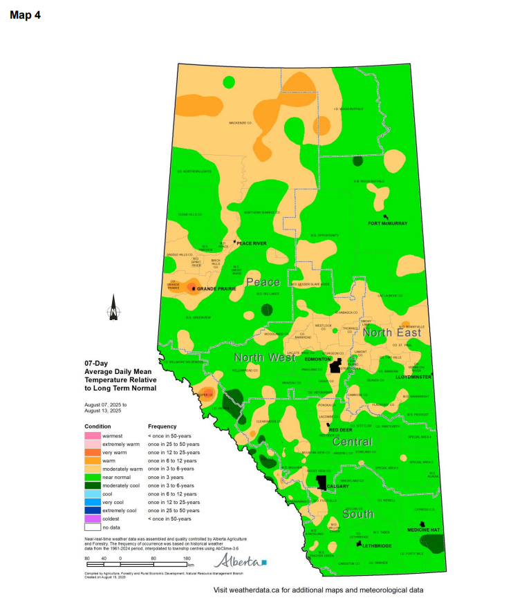
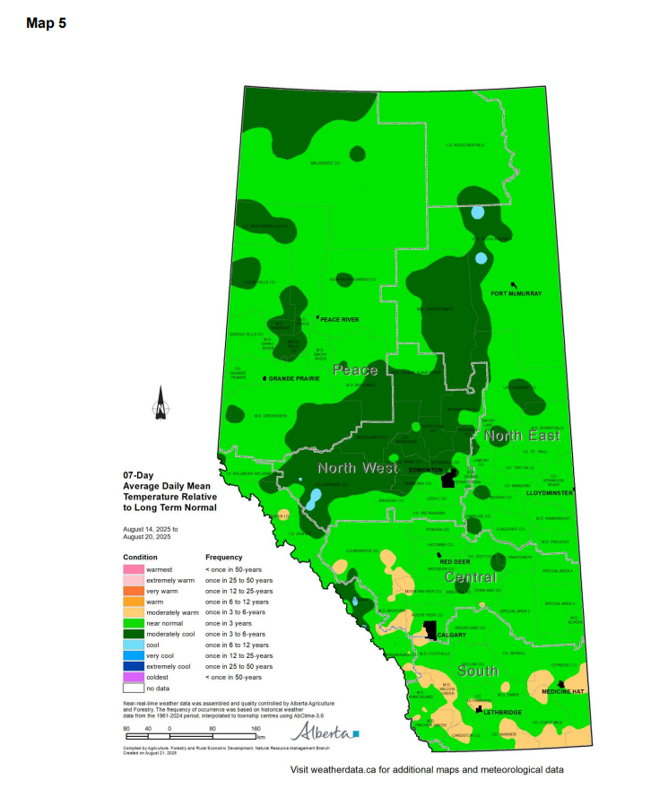
Maps 4 & 5: Over the past two weeks, average daily mean temperatures across most of the province ranged from near-normal to moderately cooler than the long-term average. A few areas in the North East, North West, and Peace Regions experienced moderately warmer temperatures two weeks ago, followed by near-normal conditions this past week.
Growing Season Trends
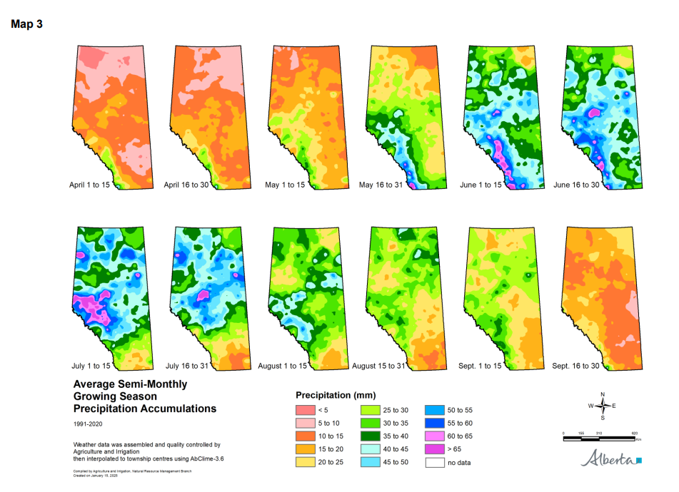
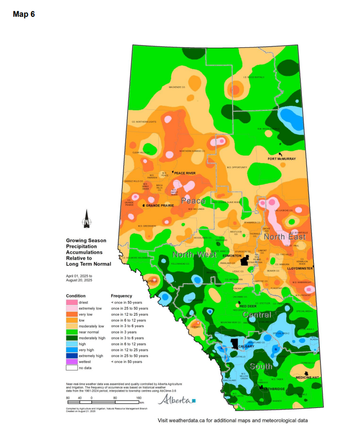
Maps 6 & 7: Precipitation received over the past two weeks has improved overall growing season accumulations in many areas across the province (Map 6).
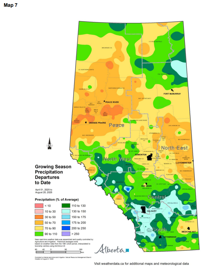
Growing season precipitation accumulations continue to trend from near-normal to above normal across most of the South, Central, and North West Regions (Map 6). Small pockets within the municipalities of Yellowhead, Rocky View, Foothills, Wheatland, Newell, and Special Areas No. 2 and No. 3 have received higher precipitation relative to the long-term average. In these areas, growing season totals range from 130% to 150% of normal (Map 7).
Parts of Forty Mile and Cypress Counties continue to experience moderately low growing season precipitation, however; cumulative totals have improved, now ranging from 70% to 90% of the long-term average (Map 7).
Growing season precipitation remains moderately to extremely low (Map 6) across northern Alberta, particularly north of a line extending through the municipalities of Provost, Flagstaff, Camrose, and Ponoka, continuing northward through Leduc, Parkland, and Barrhead, and then westward through Woodlands and Greenview. However, rainfall over the past two weeks has helped improve accumulation totals in some areas of this region.
In the North East Region, precipitation accumulation has improved, but in many areas, particularly within the municipalities of Provost, Wainwright, Bonnyville, St. Paul, Smoky Lake, Lac La Biche, and Athabasca, this remains very low to extremely low (Map 6). Current growing season totals in these areas are approximately 50% to 70% of the long-term average (Maps 7).
In the northern half of the North West Region, growing season precipitation accumulation remains moderately low to low compared to the long-term average (Map 6). Further north and west into the Peace Region, precipitation over the past two weeks has led to some improvement. However, growing season totals in most areas still range from low to very low, with cumulative amounts equivalent to 70% to 90% of the long-term average (Map 7).
As crops begin to mature, plant water uptake will decline, allowing precipitation to start recharging soil moisture reserves.
Soil Moisture Reserves
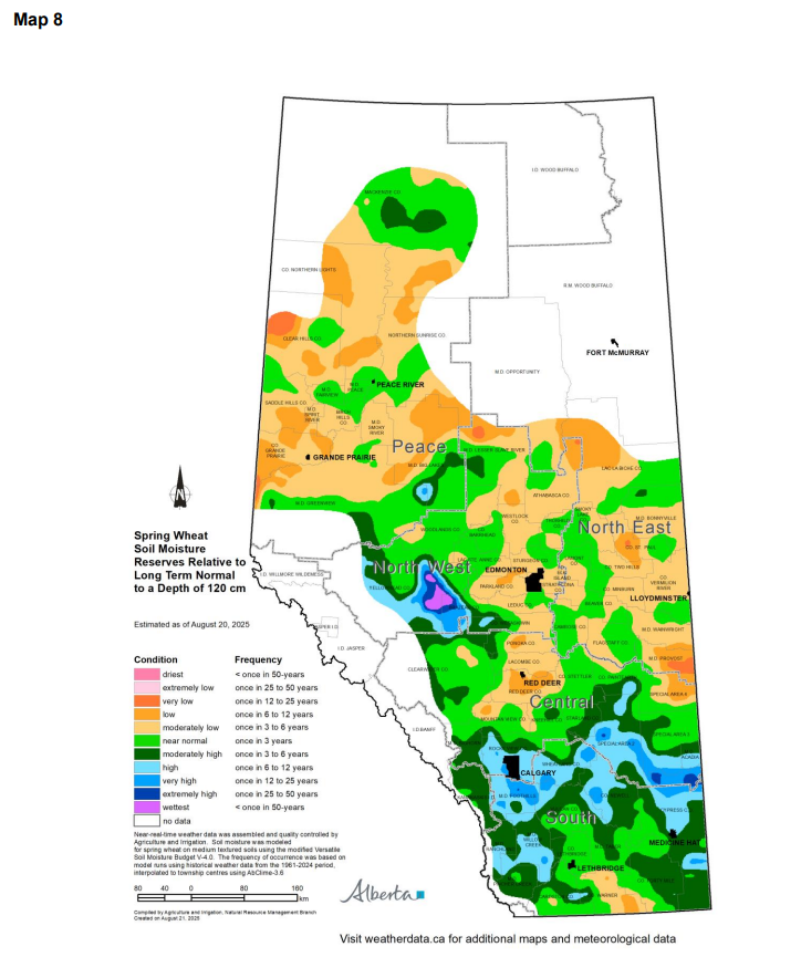
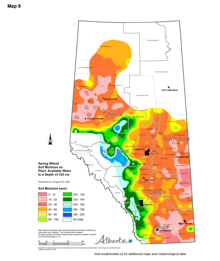
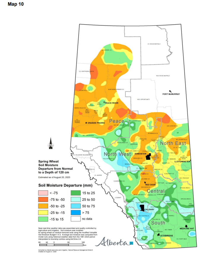
Maps 8, 9 & 10: South of a line running through the municipalities of Mountain View, Red Deer, Flagstaff, and Special Area No. 4, estimated soil moisture reserves remain normal to very high relative to the long-term average, to a depth of 120 cm (Map 8). Due to lower precipitation in recent weeks, soil moisture in localized areas within Foothills, Rocky View, Wheatland, and Special Area No. 2 has declined from extremely high to high or very high levels. In these areas, plant-available water is estimated to range from 40 to 140 mm, to a depth of 120 cm (Map 9). This translates to an additional 15 to 50 mm of moisture compared to normal (Map 10). In contrast, soil moisture reserves in the County of Warner remain moderately low to low relative to the long-term average.
Precipitation over the past two weeks has improved soil moisture reserves across the North East, North West, and Peace Regions. Most areas have improved to moderately low levels relative to the long-term average, up from extremely low or low conditions two weeks ago (Map 8). In these regions, plant-available water is estimated to range from 10 to 40 mm, to a depth of 120 cm (Map 9), representing a departure of 15 to 50 mm from normal (Map 10).
Several pockets across the North East, North West, and Peace Regions have now reached near-normal soil moisture conditions (Map 8). The most notable improvement occurred in the municipalities of Brazeau and Yellowhead, where reserves increased from near-normal or moderately low, to moderately high or among the wettest relative to the long-term average. In these areas, soil moisture reserves range from 80 to 180 mm, to a depth of 120 cm (Map 9). This is approximately 25 to 75 mm above normal (Map 10). Encouragingly, both the number and size of areas with low soil moisture reserves in the North East, North West, and Peace Regions has markedly decreased. This recent precipitation has helped reduce crop stress and, in some areas, improved soil moisture conditions.
Perspective
As of August 20, 2025, areas south of a line running from the M.D. of Provost through Brazeau County into the M.D. of Greenview, have received near-normal to above-normal growing season precipitation relative to long-term averages. Most of the South Region and parts of the Central and North West Regions are experiencing normal to high precipitation accumulation relative to long term normal. This area is experiencing normal to moderately warmer average daily mean temperatures relative to long term normal. These conditions are expected to have a positive impact on crop growth and yield potential. However, exceptions remain in portions of Cypress County, where growing season precipitation remains moderately lower relative to long term normal.
In contrast, municipalities north of this line have moderately to very low growing season precipitation relative to long-term normal. Recent rainfall over the past two weeks provided some relief across the Peace, North West, and North East Regions, improving growing season precipitation accumulation. These areas are experiencing normal to moderately warmer average daily mean temperatures relative to long term normal.
As we move into harvest, annual crop water utilization will end, and precipitation additions will begin to replenish soil moisture reserves.
Contact Us
Saddle Hills
Junction of Hwy 49 & Secondary Hwy 725
RR1, Spirit River AB
T0H 3G0
T. 780-864-3760
Fax 780-864-3904
Toll-free 1-888-864-3760
frontdesk@saddlehills.ab.ca
Sign up to our Newsletter
Stay up to date on the Saddle Hills activities, events, programs and operations by subscribing to our eNewsletters.