Moisture Update - July 31, 2025

Precipitation
Maps 1 & 2: Rainfall during the week of July 24-30, 2025 was more widespread than in previous weeks (Map 1). Significant precipitation was once again recorded along the mountains and foothills, as well as across much of the South, Central and North West Regions.
Municipalities around Calgary, including Rocky View, Wheatland, Vulcan, and Foothills Counties, received between 15 to 50 mm of precipitation over this 7-day period (Map 1). Across the South Region, from the Mountains to the Saskatchewan border, rainfall ranged from 5 to 25 mm. This precipitation is a welcome relief in parts of Forty Mile and Cypress Counties, which have been experiencing dry conditions. Rainfall was more sporadic along the southern portion of the South Region, including the municipalities of Pincher Creek, Carston, and Warner, and the south west portion of Forty Mile. This area received rainfall amounts more typical for this time of year, with totals under 5 mm (Map 2).
West of Red Deer County, municipalities received 5 to 50 mm of rainfall (Map 1). However, areas from Red Deer County east to the Saskatchewan border, saw less than 5 mm, a marked decrease compared to previous weeks.
In contrast to previous weeks, parts of the North East, North West, and the northern Peace Region (north of the M.D. of Peace River) received moisture. The North East and North West Regions received 5 to 20 mm of precipitation (Map 1), while the northern Peace Region received 5 to 50 mm, more typical for this time of year (Map 2). The moisture will help sustain current crop growth and yield, offering much needed relief from the dry conditions experienced throughout much of the season.
A band across the southern Peace Region, through the North West and North East Regions, received less than 5 mm rainfall, which is well below the normal 25 to 50 mm typically expected in late July (Map 2). Continued low rainfall is adding stress to crops across this area.


Temperature
Map 3: Over the past seven days, from July 24 to 30, average daily mean temperatures across most of the province were near normal to moderately cooler than the long-term normal (Map 3). Cooler conditions help reduce crop water demand, which in turn eases moisture stress in areas where rainfall has been limited.

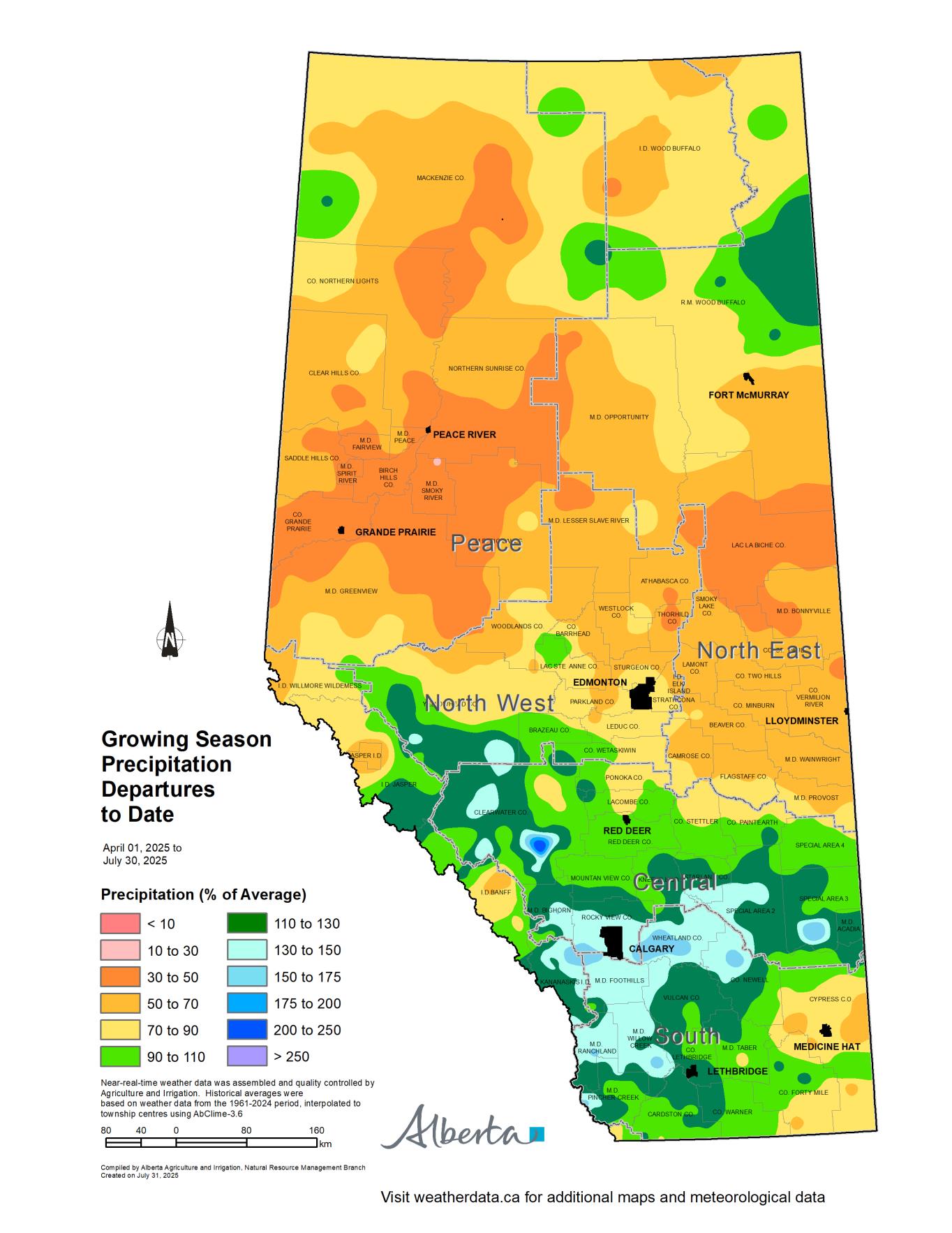
Growing Season Trends
Maps 4 & 5: Growing season precipitation accumulations continue to trend near normal in parts of the South, Central, and North West Regions (Map 4). Within these areas, some pockets have received moderately higher to higher precipitation accumulation relative to long-term normal.
Recent rainfall has improved the growing season precipitation accumulation relative to long-term normal in parts of Forty Mile and Cypress Counties. However, several areas within these Counties, continue to experience moderately low to low precipitation levels for the season, with cumulative precipitation ranging from 50% to 90% of the long-term average (Map 5).
Rainfall over the past week did not significantly alter the growing season precipitation accumulation trends across the North East, North West or Peace Regions. In the North East Region, growing season precipitation accumulation remains low to very low, with current totals at approximately 50% to 70% of the long-term normal (Maps 4 and 5). Notably, Lac La Biche County and parts of the M.D. of Bonnyville are experiencing extremely low accumulations, with totals just 30% to 50% of long-term normal.
In the northern half of the North West Region, precipitation accumulation remains moderately low to low relative to long-term normal (Map 4). Further north and west into the Peace Region, the growing season precipitation accumulation ranges from low to extremely low, equivalent to 30% to 70% of the long-term normal.
These ongoing dry conditions continue to strain crop development, and additional moisture will be needed to support crop growth and maintain yield potential through the remainder of the season.
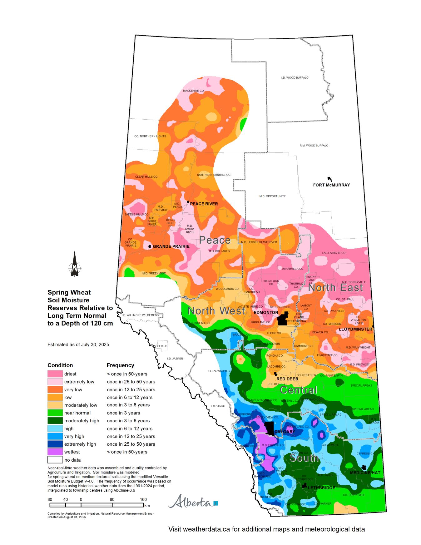

Soil Moisture Reserves
Maps 6 & 7: Historically, by this point in the growing season, soil moisture reserves have typically passed their peak, as crop water use reaches its highest levels. As crop demand begins to exceed rainfall, soil moisture enters a depletion phase.
However, this year marks a departure from historical trends. Due to above-normal July rainfall and cooler-than-average temperatures, soil moisture reserves in the Central and South Regions are estimated to be normal to very high relative to the long-term normal, to a depth of 120 cm (Map 6). Notably, localized areas in the municipalities of Ranchland, Foothills, Rocky View, and Wheatland Counties, show extremely high soil moisture reserves relative to long-term normal. In these regions, plant-available water is estimated to range from 60 to 180 mm, to a depth of 120 cm (Map 7).
In contrast, areas north of a line running from the M.D. of Provost west to Red Deer County and north to Parkland and Yellowhead Counties, are estimated to have moderately low to extremely low soil moisture reserves relative to long-term normal (Map 6). This includes large portions of the North East, North West, and Peace Regions, which are currently experiencing the lowest soil moisture levels relative to long-term normal. In these areas, plant-available water, to a depth of 120 cm, is estimated to be below 60 mm (Map 7). Timely rainfall across these areas will be essential to meet crop moisture needs and mitigate further stress as the season progresses.
Perspective
Most of the South Region and parts of the Central Region continue to experience normal to above-normal precipitation, coupled with normal to cooler than average temperatures. These conditions are expected to have a very positive impact on crop growth and yield potential. However, exceptions remain in portions of Cypress and Forty Mile Counties, where growing season precipitation accumulations are still moderately lower to lower than normal.
Although delayed compared to typical patterns, rainfall did occur across areas north of the Trans-Canada Highway. However, the recent moisture did not change the overall growing season precipitation accumulations to date.
As of July 30, 2025, areas south of a line between the M.D.s of Provost through Brazeau County, and into Yellowhead County, have received near-normal to above-normal growing season precipitation. In contrast, municipalities north of this line are experiencing moderately to extremely low seasonal precipitation accumulations relative to the long-term normal.
While this past week’s precipitation provided some relieve across the Peace, North West, and North East Regions, continued and timely precipitation will be essential to support crops through to harvest.
Contact Us
Saddle Hills
Junction of Hwy 49 & Secondary Hwy 725
RR1, Spirit River AB
T0H 3G0
T. 780-864-3760
Fax 780-864-3904
Toll-free 1-888-864-3760
frontdesk@saddlehills.ab.ca
Sign up to our Newsletter
Stay up to date on the Saddle Hills activities, events, programs and operations by subscribing to our eNewsletters.