Moisture Update - May 21, 2025
30-Day Synopsis
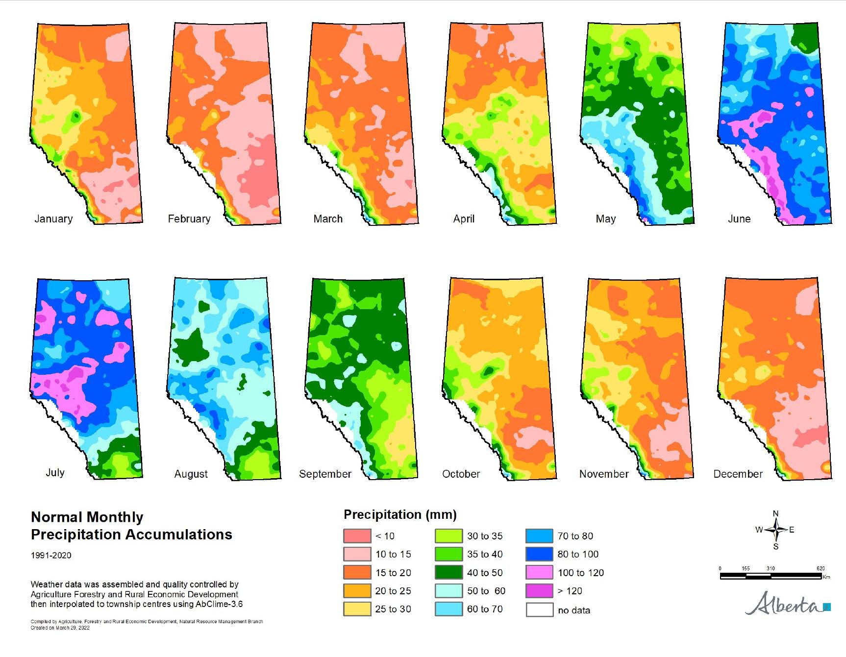
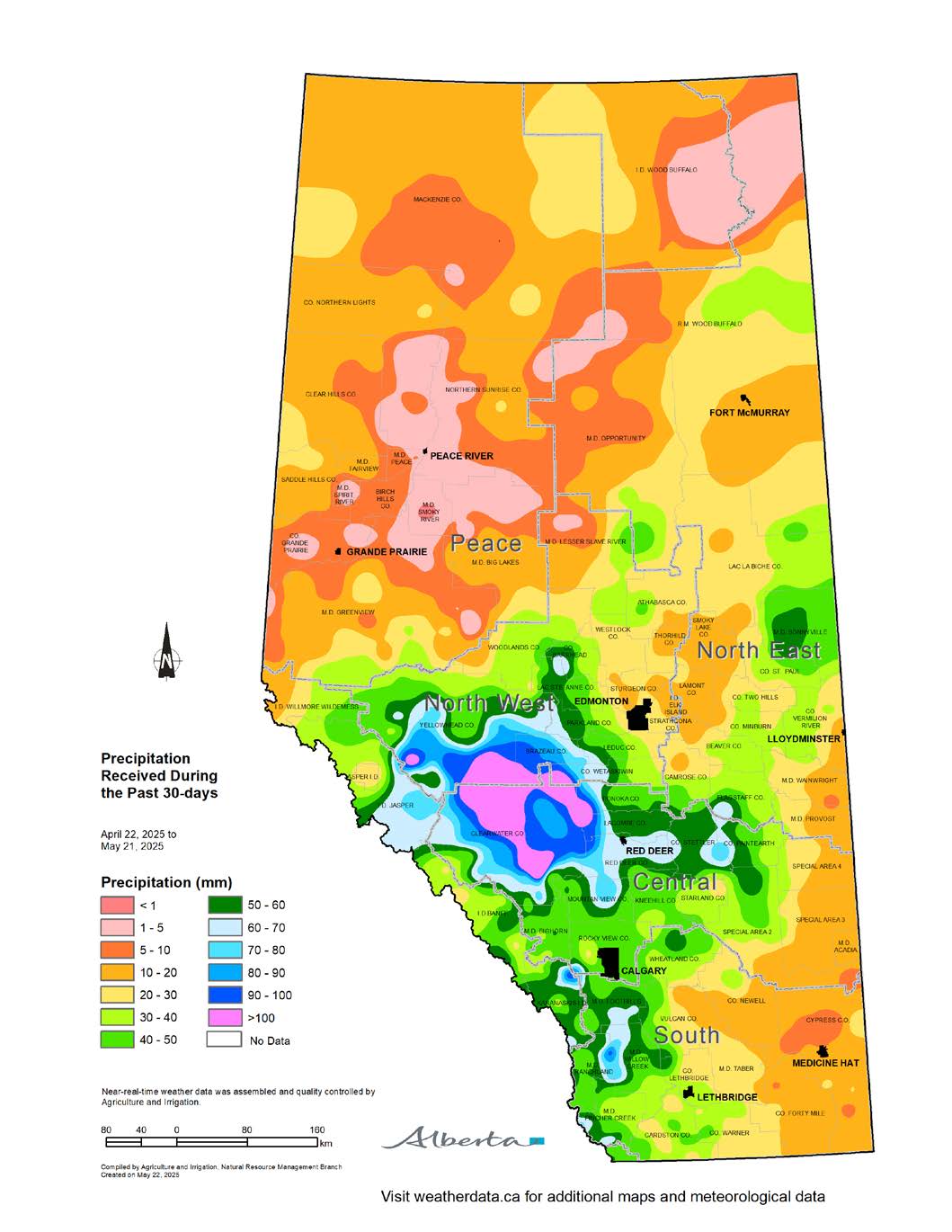
Maps 1, 2 & 3: As spring advances, Alberta typically enters a wetter phase, beginning in May (Map 1).
There are notable regional differences in precipitation between April 22 and May 21, 2025. The western portion of the province, west of the Highway 2 corridor, received more than 30 mm of precipitation in the last 30 days (Map 2). The heaviest rainfall was received west of Red Deer, with Clearwater County receiving more than 70 mm of precipitation. East of Red Deer, Flagstaff County, along with the Counties of Stettler and Paintearth, received between 30 and 60 mm of precipitation.
Lower levels of precipitation, 5 to 20 mm, were received across the eastern portion of the province. The Peace Region received less than 20 mm in the last 30 days. A significant area around the central Peace Region, as well as several pockets across the region, received less than 5 mm of precipitation. The northern Peace Region, around High Level and Fort Vermillion, received 5 to 10 mm of precipitation.
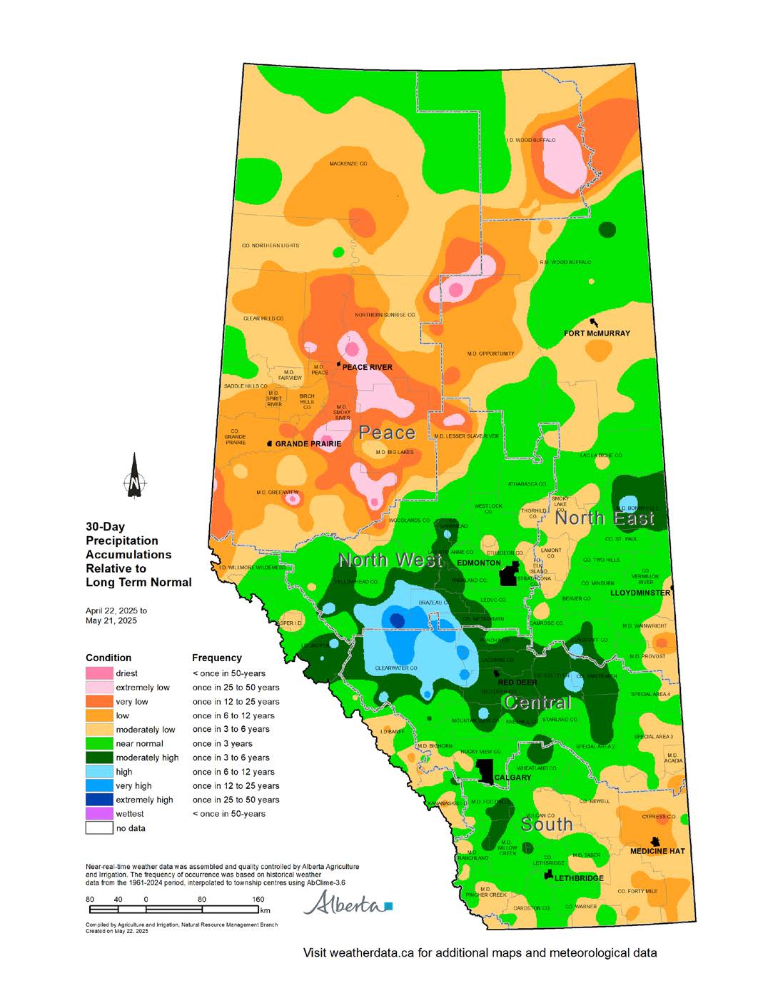
Comparing recent precipitation levels to long-term normal across Alberta over the past 30 days, reveals significant spatial variability (Map 3). Relative to normal, the last 30-day precipitation accumulations trended from near-normal to higher-than-normal for most of the Central, North West, and North East Regions, as well as the western portion of the South Region. A large area around Clearwater County, extending into Brazeau, Ponoka, Lacombe, and Red Deer Counties, and the County of Wetaskiwin, received moderately high (once in 3 to 6-year highs) to high (once in 6 to 12-year highs) 30-day precipitation relative to long-term normal.
The eastern portion of the province, including parts of the North East, Central, and South Regions, has several areas with moderately low (one in 3 to 6-year lows) precipitation accumulations relative to normal. A few areas in Cypress County and the County of Forty Mile, have low (once in 6 to 12-year lows) precipitation accumulations relative to normal.
Most of the Peace Region is also reporting 30-day precipitation accumulations relative to long-term normal, from moderately low (one in 3 to 6-year lows) to extremely low (once in 25 to 50-year lows). The lowest 30-day precipitation accumulations relative to long-term normal are in the M.D.s of Greenview, Big Lakes, and Smoky River, as well as Northern Sunrise County.

Growing Season Precipitation Trends
Map 4: The growing season precipitation accumulations, from April through October, vary significantly across Alberta, with roughly half the province experiencing near-normal conditions, and the other half showing notable deviations from long-term norms.
The Central Region, the western half of the South Region, and the North West Region have near-normal (once in 3-years) to moderately high (once in 3 to 6-year highs) growing season precipitation accumulations relative to long-term normal (Map 4). Pockets of high (one in 6 to 12-year highs) to very high (once in 12 to 25-year highs) precipitation relative to normal are scattered through the western portion of this area.
Cypress County along with much of the County of Forty Mile, has moderately low (once in 3 to 6-year lows) to low (once in 6 to 12-year lows) growing season accumulations relative to normal.
The North East Region, from Edmonton to the Saskatchewan border, also has moderately low (once in 3 to 6-year lows) growing season accumulations relative to normal. Pockets through Beaver, Lamont, Thorhild, and Smoky Lake Counties have low (once in 6 to 12-year lows) growing season accumulations relative to normal.
The growing season accumulations relative to normal across the Peace Region, ranges from low (once in 6 to 12-year lows) to extremely low (once in 25 to 50-year lows). A few pockets across the M.D.s of Greenview, Big Lakes, and Smoky River have longer than once in 50-year growing season accumulations relative to normal. The exception is the northern Peace Region, in Mackenzie County, which has near-normal (once in 3-year) precipitation accumulations relative to normal.
About half of Alberta has experienced a reasonably typical growing season so far, in terms of precipitation.
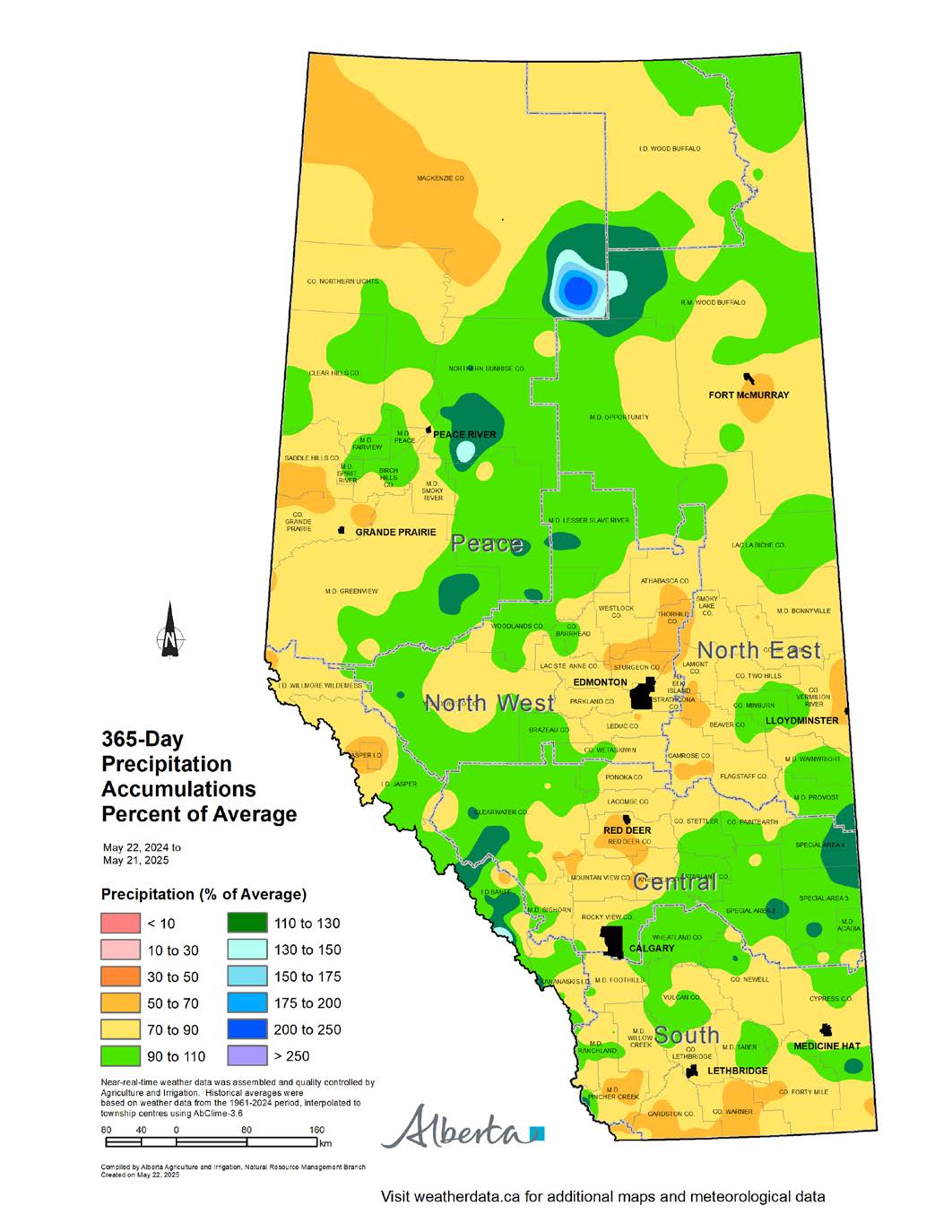
365-Day Precipitation Trends
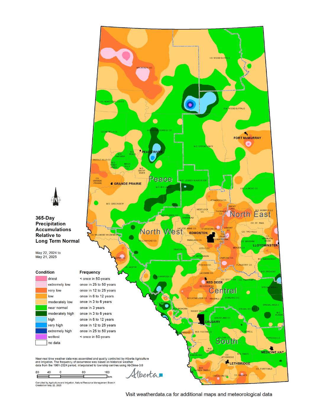
Maps 5 & 6: Looking back over the past 365 days, precipitation accumulations relative to normal (Map 5) have changed since the last report. The areas that had reported moderately low (once in 3 to 6-year) to low (once in 6 to 12-year) precipitation accumulations relative to normal have increased. These areas are now reporting 365-day precipitation accumulations of 70 to 90% relative to average (Map 6).
There are areas in each region experiencing very low (once in 12 to 25-year lows) 365-day precipitation accumulations relative to normal. Small pockets across the province have extremely low precipitation accumulations (once in 25 to 50-year lows) relative to long-term normal. The 365-day precipitation accumulations in these areas are approximately 50 to 70% relative to average.
Conversely, the eastern half of the Central Region, parts of the South and North West Regions, and the eastern portion of the Peace Region, have near normal 365-day precipitation accumulations relative to long-term normal. This translates to precipitation accumulations between 90 to 110% of average, which is positive news for those farming in these areas.
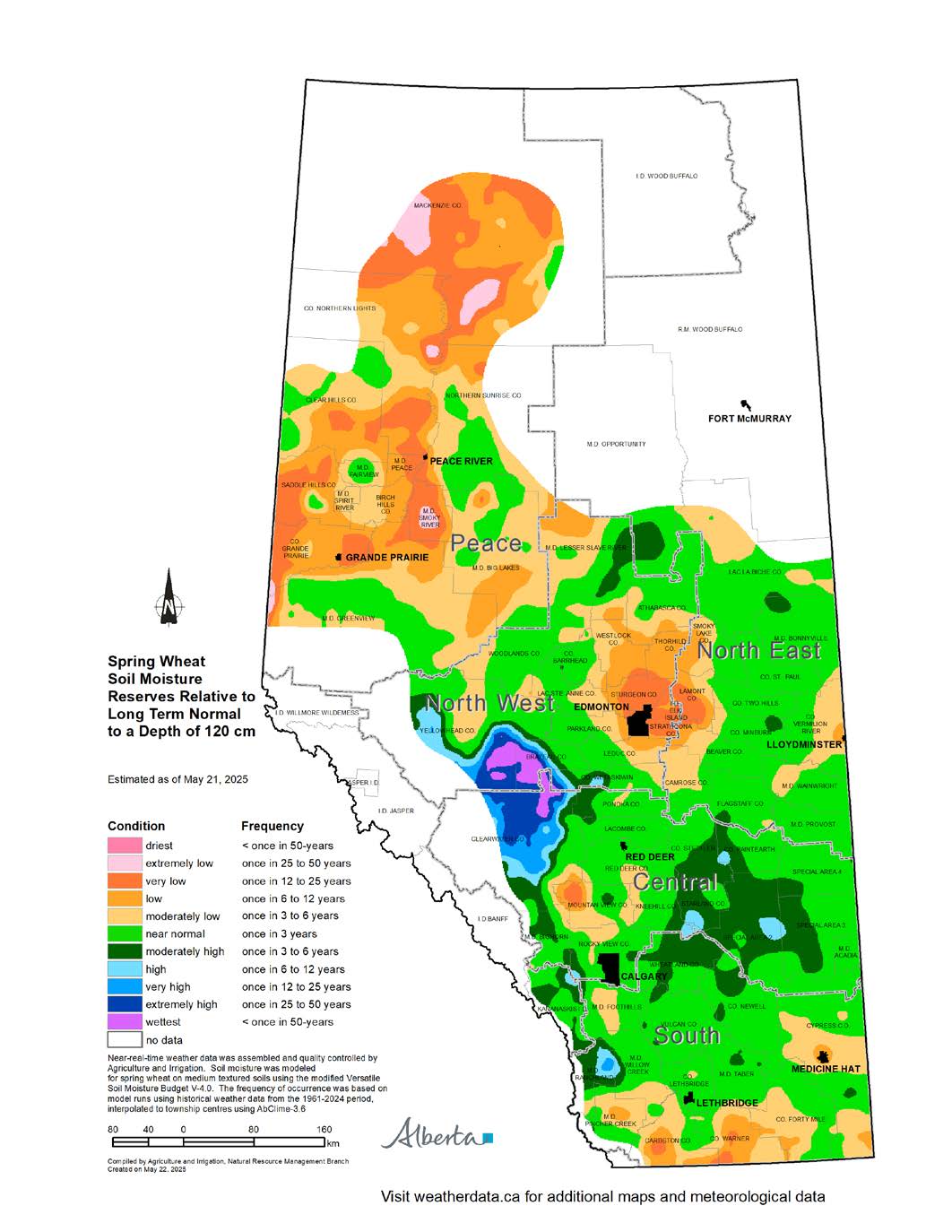
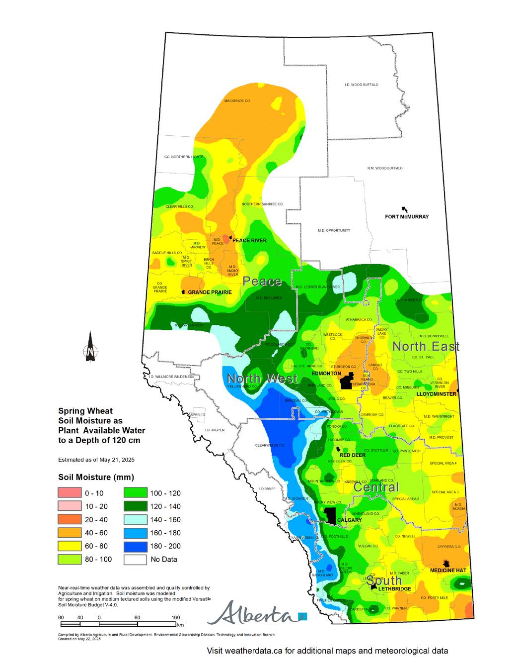
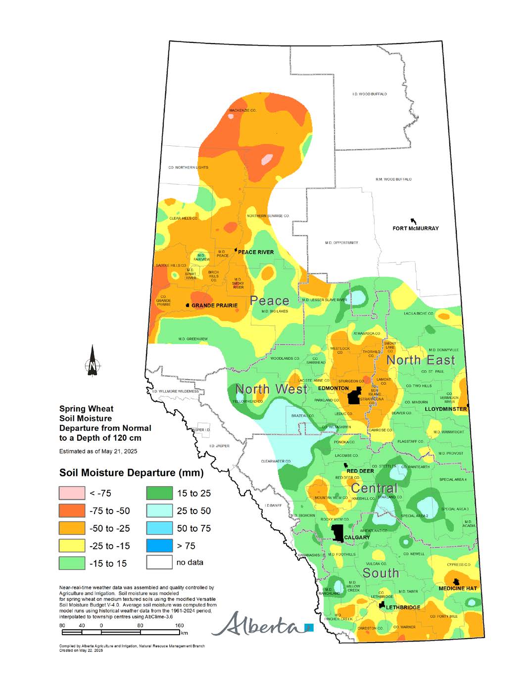
Soil Moisture Reserves
Maps 7, 8 & 9: It is estimated that many fields in southern and central Alberta, are experiencing near-normal soil moisture levels (Map 7). A large area, from Wheatland County north to the County of Stettler, and east into the Special Areas, is estimated to have moderately high (once in 3 to 6-year highs) soil moisture reserves relative to normal. It is estimated that this area has between 60 to 80 mm of water in 120 cm depth of soil ready to support early growth (Map 8). This is estimated to be from near-normal, to 25 mm above normal, soil moisture levels (Map 9).
In contrast, soil moisture in the County of Forty Mile, east to the M.D. of Pincher Creek, is estimated to be moderately low (once in 3 to 6-year lows) to low (once in 6 to 12-year lows) (Map 7).
Estimated soil moisture reserves appear to have improved around Red Deer. An area through Mountain View County, and into Red Deer County, is estimated to be moderately low (once in 3 to 6-year lows) to low (once in 6 to 12-year lows) (Map 7).
Moderately low (once in 3 to 6-year lows) to very low (once in 12 to 25-year lows) areas persist around Edmonton, through Westlock, Thorhild, Strathcona, and Sturgeon Counties. Similar conditions are also estimated to persist across the Peace Region. This area is estimated to have 40 to 60 mm of soil moisture as plant available water to a depth of 120 cm (Map 8). This represents a 25% to 50% deficit from normal soil moisture levels (Map 9).
Perspective
As spring moisture begins to accumulate, soil moisture reserves will improve. Winter is inherently the driest season, and its influence on soil moisture and agricultural productivity is minimal.
The months of May through July are pivotal. They contribute the bulk of moisture needed for crop germination, vegetative growth, and yield formation. What happens in these months will be the true determinant of the 2025 cropping season’s outcome.
Alberta is now entering its historically wetter period. There remains ample opportunity to improve moisture conditions, provided rainfall arrives in a timely and sufficient manner.
Contact Us
Saddle Hills
Junction of Hwy 49 & Secondary Hwy 725
RR1, Spirit River AB
T0H 3G0
T. 780-864-3760
Fax 780-864-3904
Toll-free 1-888-864-3760
frontdesk@saddlehills.ab.ca
Sign up to our Newsletter
Stay up to date on the Saddle Hills activities, events, programs and operations by subscribing to our eNewsletters.