Moisture Update - May 7, 2026

Precipitation
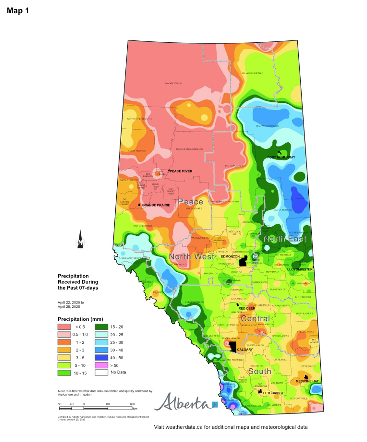
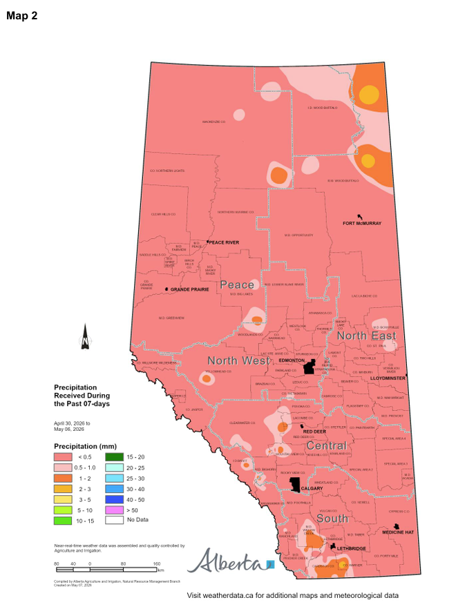
Since the April 22 report, scattered precipitation has occurred across Alberta (Maps 1 and 2). Precipitation
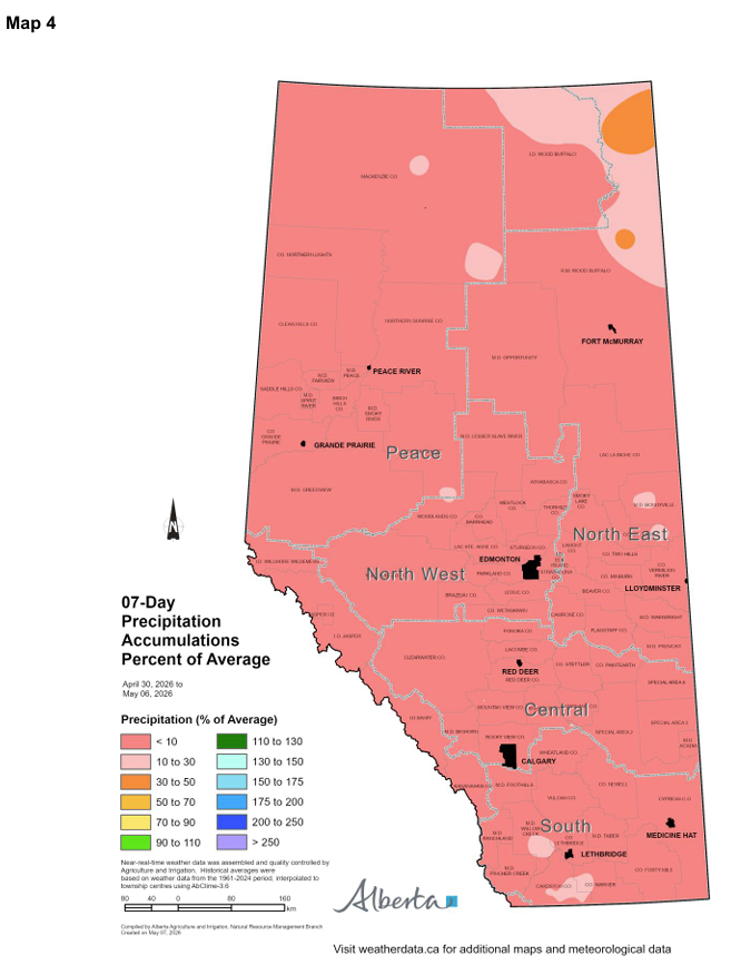
totals were notably higher during the weeks of April 22 and 29 than during the period from April 30 to May 6. In fact, very little precipitation fell across most of the province between April 30 and May 6 (Map 4).
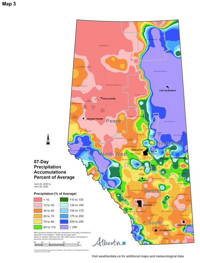
The highest precipitation amounts during the week of April 22 to 29 fell largely in non‑agricultural areas. Municipalities extending from Greenview south along The mountains and foothills to Cardston received between 10 and 40 mm of precipitation, with isolated areas in Ranchland and Pincher Creek exceeding 40 mm. In the North East Region, municipalities from Vermilion River east to Smoky Lake and north to Wood Buffalo also received 10 to 40 mm, with one isolated area receiving 40 to 50 mm. Precipitation totals during this week exceeded 200 per cent of normal in these areas (Map 3).
Some agricultural areas in portions of the North East, Central, and South Regions did receive precipitation during the week of April 22. Amounts generally ranged from 3 to 10 mm, which is below average for most locations at this time of year (Maps 1 and 3).
The lowest precipitation totals—less than 3 mm—were observed across much of the Peace Region (Map 1). This represents less than 30 per cent of average precipitation for the region and time period (Maps 1 and 3). Similarly low totals were recorded across large portions of the North West Region and in parts of the Central and South Regions.
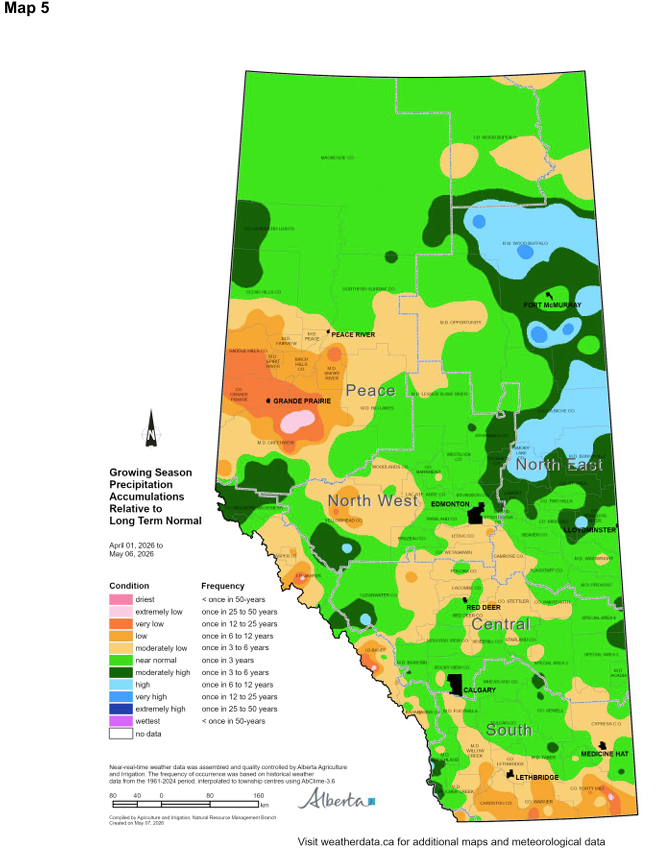
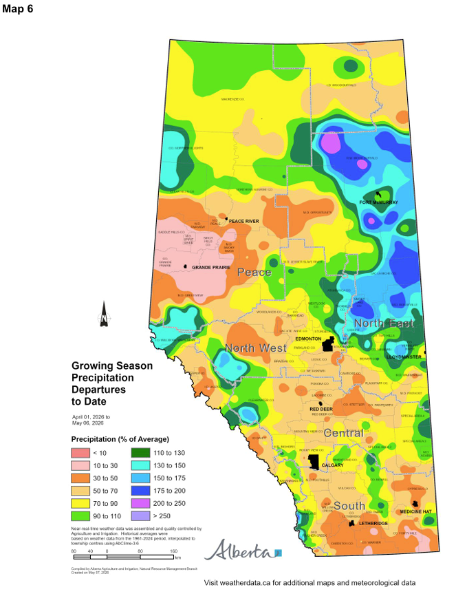
Growing‑season precipitation accumulation to date (April 1 to May 6) has been moderately high to high across several municipalities in the North East Region, including parts of Vermilion River, St. Paul, Lamont, Thorhild, Athabasca, Smoky Lake, Bonnyville, Lac La Biche, and Wood Buffalo (Map 5). These areas have received approximately 110 to 175 per cent of normal precipitation so far this growing season (Map 6). Much of the remaining North East Region has received near‑normal growing‑season precipitation.
North of Edmonton, as well as in portions of the North West Region, growing‑season precipitation has been near normal so far this year (Map 5). However, a large area in the central part of the North West Region— including Yellowhead, Woodlands, and parts of Lac Ste. Anne, Parkland, and Brazeau Counties—is experiencing moderately low precipitation accumulation. These areas have received roughly 30 to 90 per cent of normal precipitation to date (Map 6).
The Peace Region received above‑normal precipitation during the previous cold season, with the highest totals observed in the central and northern Peace. So far this growing season, areas north of the Peace River have generally received near‑normal precipitation (Map 5). In contrast, much of the southern Peace Region; from Clear Hills south to Greenview and east through Big Lakes and Opportunity to the southern portion of Northern Sunrise, has received below‑normal precipitation. These areas have accumulated less than 50 per cent of normal growing‑season precipitation to date (Map 6).
In the Central Region, eastern and southern areas, along with a few locations in the South Region, have received near‑normal growing‑season precipitation (Map 5). However, municipalities in the core of the Central Region—including Leduc, Ponoka, Lacombe, Stettler, Camrose, and parts of Red Deer and Clearview—have received below‑normal precipitation. Much of this area has accumulated less than 70 per cent of normal precipitation so far this growing season (Map 6).
Most of the South Region is also experiencing below-normal precipitation accumulation (Map 5). Parts of the municipalities of Cardston, Warner, Forty Mile, and Cypress have received less than 50 per cent of normal growing-season precipitation to date (Map 6).
It is important to note that typical spring precipitation across Alberta is relatively limited; April precipitation usually totals only 15 to 30 mm across much of the province (Map 7). Historically, precipitation increases substantially in May. Long-term forecasts are currently indicating the potential for above-normal rainfall during May and June.
Temperature
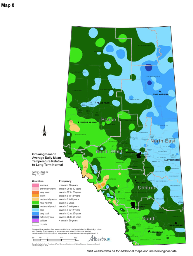
Average daily temperatures so far this growing season have been near long‑term normal in municipalities
west of a line extending south from Saddle Hills through Greenview, Brazeau, Mountain View, Rocky View, Foothills, Lethbridge, Taber, and Forty Mile (Map 8).
Municipalities east of this line have experienced moderately cool to cool average daily mean temperatures relative to long‑term normal (Map 8). The coolest conditions occurred along the eastern border, extending from Special Areas and Acadia northward through Beaver and Westlock, and into Opportunity and Wood Buffalo.
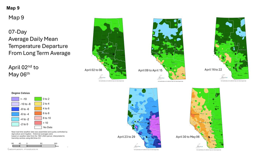
Overall, the growing‑season 7‑day average daily mean temperature has ranged from near normal to
moderately cooler than long‑term normal (Map 9). So far this growing season, the first three weeks
experienced near normal to moderately cooler temperatures. One week the province experienced very to extremely cool temperatures relative to normal, while another week was moderately warmer than normal.
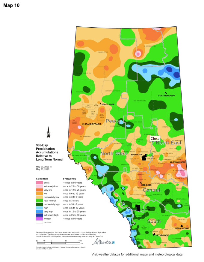
365-Day Precipitation Trends
Year‑over‑year conditions remain highly variable, with significant precipitation deficits persisting across much
of Alberta (Map 10). In most of the Central, North East, North West, and Peace Regions, 365‑day precipitation totals range from moderately low to very low relative to long‑term normal.
Several areas; including portions of the municipalities of Grande Prairie, Greenview, Northern Lights,
Camrose, Flagstaff, Beaver, Wainwright, and Provost; are experiencing very to extremely low 365‑day
precipitation accumulations. In contrast, only a few isolated areas across the province show normal to moderately high 365‑day precipitation totals compared with long‑term normal (Map 10).
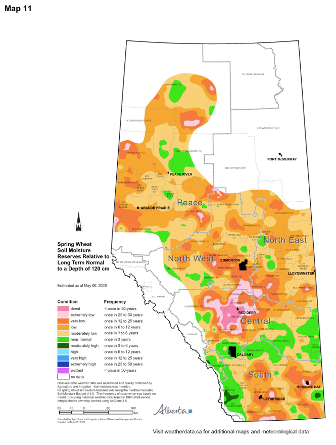
Soil Moisture Reserves
Estimated soil moisture reserves as of May 6 have changed since the previous report. Spring wheat soil
moisture reserves, assessed to a depth of 120 cm and expressed relative to long‑term normal, have begun to improve in parts of the Peace Region and in northern portions of the North West and North East Regions as cold‑season precipitation continues to infiltrate the soil profile (Map 11). Despite these improvements, soil moisture reserves across much of this area remain moderately to very low compared with long‑term normals.
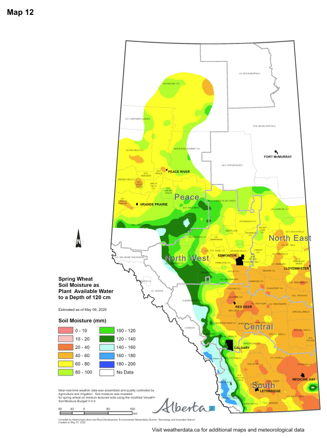
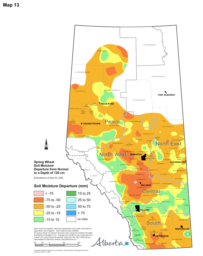
Across the Peace Region and northern portions of the North West and North East Regions, soil moisture
reserves are estimated to be 60 mm or greater (Map 12). This corresponds to a soil moisture departure of approximately ‑15 to ‑50 mm relative to normal at the 120 cm depth (Map 13).
South of a line running through the municipalities of Woodlands, Barrhead, Westlock, Thorhild, Smoky Lake, and Bonnyville, spring wheat soil moisture reserves have generally declined relative to long‑term normal (Map 11). The largest declines are estimated along the southern border of the province, and particularly in and around the Red Deer area.
In parts of the agricultural region south of Edmonton, estimated soil moisture reserves are less than 80 mm, with most areas below 60 mm at the 120 cm depth (Map 12). While some locations show only minor departures of ‑5 to ‑15 mm from normal, many areas are experiencing more substantial deficits ranging from ‑25 to ‑75 mm (Map 13).

Perspective
Alberta’s growing season is just beginning, and the province’s wettest period is still ahead (Map 7). From
an agricultural perspective, May, June, and July are the most critical months for moisture, accounting for
more than 50 per cent of annual precipitation in the Central Region and at least 40 per cent across much of
the Peace Region (Map 14).
Current conditions have been favourable, allowing early fieldwork and seeding to begin and progress rapidly across much of the province. Forecasts continue to suggest the potential for additional rainfall in the coming weeks.
For now, patience remains important, with the expectation that timely spring precipitation will support crop development and help replenish soil moisture reserves, which are essential later in the growing season.
Sign up to our Newsletter
Stay up to date on the Saddle Hills activities, events, programs and operations by subscribing to our eNewsletters.