Moisture Update - April 30, 2025
30-Day Synopsis
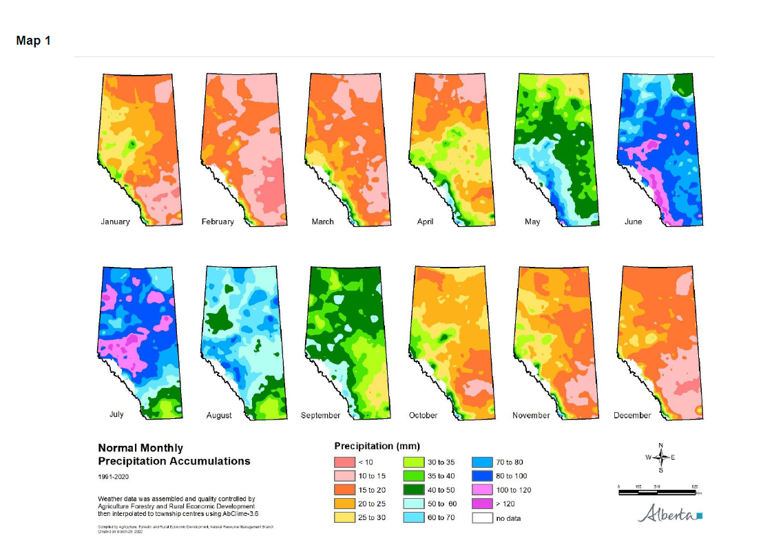
Maps 1, 2 & 3: Typically, April is the time of transition from winter to spring, as there is a shift towards wetter conditions in Alberta (Map 1).
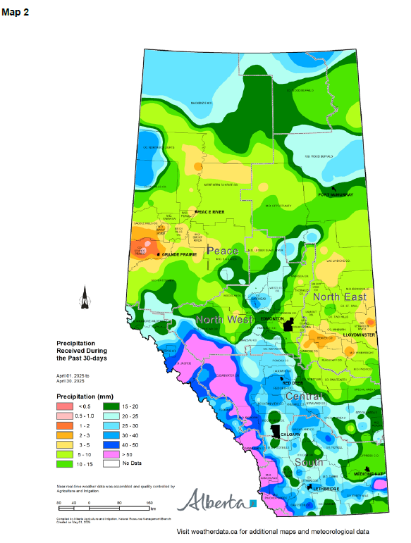
Although there are notable regional differences in precipitation, between March 25 and April 30, a significant portion of the province received more than 15 mm of precipitation (Map 2). Southern Alberta, from Cypress County west to the Central Region, received 20 to 25 mm, while an area north-west of Calgary, up through the County of Wetaskiwin, received anywhere between 30 and 40 mm, and the mountains received more than 40 mm of precipitation.
Lower levels of precipitation were received in the North East Region and parts of the north-east Central Region. An area stretching from the County of Stettler north to Athabasca County and to the Saskatchewan border received between 5 and 15 mm of precipitation. Pockets within the area only received 2 to 5 mm of precipitation.
The area around Peace River also received 5 to 10 mm of precipitation, while the northern Peace Region, around High Level and Fort Vermillion, received in the range of 15 to 25 mm. The area east and west of Grande Prairie received very little precipitation, reporting less than 3 mm.
This pattern indicates a typical seasonal transition, with moisture beginning to build, especially in the South and Central Regions, including the mountainous areas, while northern areas remain drier.
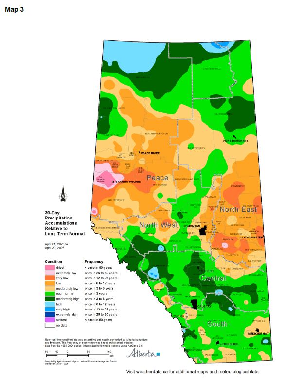
Comparing recent precipitation levels to long-term normal levels across Alberta over the past 30 days, revealed significant spatial variability (Map 3). Relative to normal, the last 30-day precipitation accumulations trended near normal to higher than normal for most of the Central and South Regions, as well as an area north and east of Edmonton, and the very northern Peace Region.
The area running from Lacombe County south and east to Wheatland County, experienced moderately high (once in 3 to 6-year highs) precipitation accumulations relative to long term normal. There are a few areas within the Central and South Regions reporting low (once in 3 to 6-year lows) precipitation accumulations relative to normal.
The North East Region, plus the north-east portion of the Central Region, are reporting moderately low (one in 3 to 6-year lows) to very low (once in 12 to 25-year lows) precipitation compared to normal. The North West Region, as well as most of the Peach Region, is also reporting moderately low (one in 3 to 6-year lows) to very low (once in 12 to 25-year lows) 30-day precipitation accumulations relative to long-term normal. A pocket west of Grande Prairie is reporting extremely low (once in 25 to 50-years) precipitation accumulations relative to normal.

Winter Precipitation Trends
Map 4: In the winter season, from November through April, precipitation accumulations varied spatially across the province, with areas experiencing both near-normal and below-normal conditions (Map 4). The east half of the Central and South Region, the North West Region, and the south Peace Region, all had near normal winter precipitation accumulations. Pockets of moderately low (one in 3 to 6-year lows) precipitation relative to normal were also scattered through this area.
A large area along the foothills, running from Cardston County to northeast of Red Deer, across to the County of Paintearth, and north through Beaver County into Lamont County, reported moderately low (once in 3 to 6-year lows) winter accumulations relative to normal.
The central Peace Region from Saddle Hills County to the M.D. of Opportunity and north into Mackenzie County, also reported moderately low (once in 3 to 6-year lows) precipitation relative to long-term normal. Pockets across this area also reported low (once in 6 to 12-year lows) precipitation relative to long term normal.
About half of Alberta had a reasonably typical winter in terms of precipitation, although key agricultural and foothill areas saw drier-than-usual conditions.
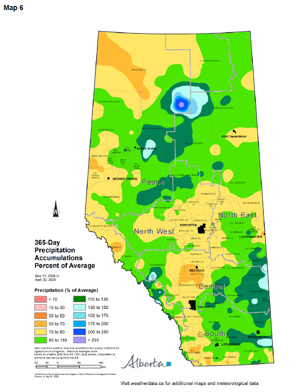
365-Day Precipitation Trends
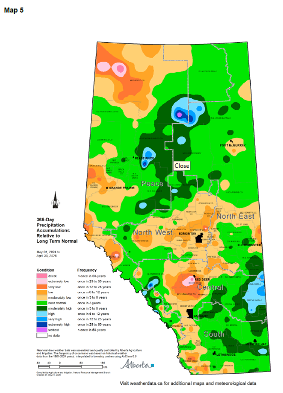
Maps 5 & 6: Looking back over the past 365 days, precipitation accumulations relative to normal have not changed much since the last report (Map 5). A large portion of the agricultural area continues to report moderately low (once in 3 to 6 years) to low (once in 6 to 12 years) precipitation accumulations relative to normal. This includes areas through Cardston County and the M.D. of Pincher Creek in the South Region, the west half of the Central Region, the North West Region, parts of the North East Region, and the south-west and northern parts of the Peace Region. These areas are reporting a 365-day precipitation accumulation of 70 to 90% of average (Map 6).
Once in 12 to 25-year lows continue to persist in and around Red Deer and Mountain View Counties (Map 5). A small area southwest of Red Deer, is reporting a once in 25 to 50-year low in precipitation accumulations relative to the long-term normal. This area is reporting 365-day precipitation accumulations of 50 to 70% of average (Map 6).
Conversely, the central part of the North East Region, eastern half of the Central Region, and most of the South Region, are reporting near normal (once in 3 years) to moderately higher than normal (once in 3 to 6 years highs) precipitation accumulations relative to long term normal (Map 5). Here, areas are reporting precipitation accumulations of 90 to 130% of average, which is positive news for those farming in these areas (Map 6).
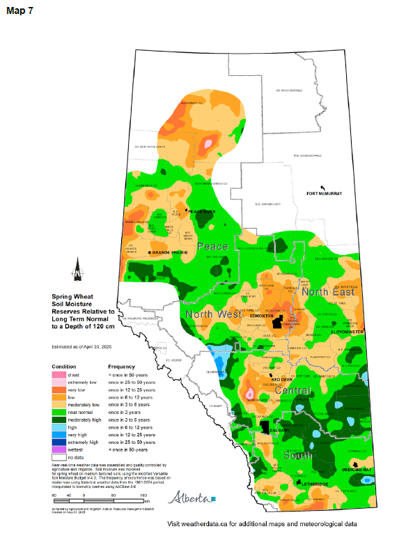
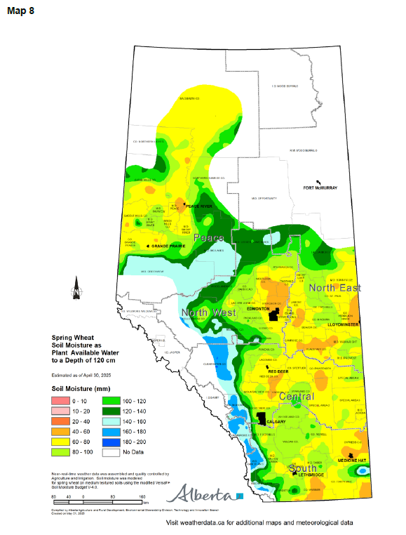
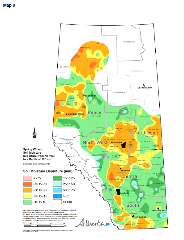
Soil Moisture Reserves
Maps 7, 8 & 9: It is estimated that many fields in the South and Central Regions are experiencing near-normal soil moisture levels (Map 7). A large area from the M.D. of Taber north to Starland County, and east into the Special Areas, is estimated to have moderately high (once in 3 to 6-year highs) soil moisture reserves. It is estimated this area has between 60 to 80 mm of water in 120 cm depth of soil ready to support early growth (Map 8). This is estimated to be 15 to 25 mm above normal soil moisture levels (Map 9).
In contrast, soil moisture in the County of Warner, east to the M.D. of Pincher Creek, and north to the M.D. of Foothills, is estimated to be moderately low to very low, equating to once-in-3-to-25-year lows (Map 7). Similarly dry conditions extend across the west Central Region, North West, Peace, and parts of the North East Regions, with less than 80 mm of available moisture in the top 120 cm of soil (Map 8). This represents a 15% to 50% deficit from normal levels (Map 9).
Perspective
Even with above-average winter precipitation, it rarely replenishes deep soil moisture or reverses long-term deficits. Winter is inherently the driest season, so its influence on soil moisture and agricultural productivity is minimal.
The months of May through July are pivotal. They contribute the bulk of moisture needed for crop germination, vegetative growth, and yield formation. What happens in these months will be the true determinant of the 2025 cropping season’s outcome.
Alberta is now entering its historically wetter period. There remains ample opportunity to improve moisture conditions, provided rainfall arrives in a timely and sufficient manner.
Contact Us
Saddle Hills
Junction of Hwy 49 & Secondary Hwy 725
RR1, Spirit River AB
T0H 3G0
T. 780-864-3760
Fax 780-864-3904
Toll-free 1-888-864-3760
frontdesk@saddlehills.ab.ca
Sign up to our Newsletter
Stay up to date on the Saddle Hills activities, events, programs and operations by subscribing to our eNewsletters.